

Mullaghmeen [Mullach Min]
Good walks are even better shared.
N4779 : Mullaghmeen Forest Walks -Path running E from Mullaghmeen Hill
Colin Park Photo source
Overview
Mullaghmeen [Mullach Min]
Situated in the tranquil countryside of County Westmeath, Mullaghmeen, or Mullach Min, rises to an elevation of 261 meters. Despite its modest height, this charming Marilyn offers hikers a delightful experience marked by stunning views and lush woodland trails.
Geology
Mullaghmeen's geological makeup consists chiefly of sedimentary rocks, demonstrating the area’s rich prehistoric aquatic past. The rolling hills and valleys were sculpted by the forces of glaciation, creating a landscape that is both beautiful and intriguing. The path leading to the summit is predominantly forested, inviting you to immerse yourself in nature.
Routes
The Mullaghmeen Trail is the primary route that takes hikers on a circular journey of approximately 5.5 km. This moderate trek is ideal for those looking to enjoy a pleasant day outdoors. Expect a well-maintained trail that meanders through charming woodlands before ascending to the summit.
Summit Features
At the summit, you’ll be greeted by a sizeable stone cairn and a wooden observation tower. Climbing the tower provides a fantastic vantage point and an excellent photo opportunity. Who knew summiting could be this Instagrammable?
Terrain Type
The terrain is predominantly uneven with sections of rocky paths intertwined with flat forest floors. Keep an eye on your footing and watch out for those cheeky roots trying to trip you up!
Views
The views from Mullaghmeen are nothing short of spectacular. When the skies are clear, the distant Mourne Mountains and the Slieve Bloom range appear majestic, framed by the rolling landscapes of Westmeath. Autumn is especially glorious as the foliage transforms into a palette of warm hues, while spring offers vibrant greenery and the reawakening of the flora.
Hazards
While Mullaghmeen is accessible to most hikers, the uneven terrain demands some caution. Loose rocks can pose tripping hazards, so a bit of attentiveness will go a long way in keeping your ankles intact.
Nearby Summits
Just a stone's throw away is Lough Sheever, an appealing bump on the horizon, standing at 230 meters. It’s definitely worth a visit for those keen on extending their hiking adventures.
Access
The nearest parking area is conveniently located at the entrance to Mullaghmeen Woods. It’s spacious enough for visitors. Public transport in this area is limited, so a car is advisable. The nearest stop is in Ballinalack, which is about 5 km away – a perfect excuse for a wander before your trek!
Facilities
While you won’t find facilities up on the mountain, the nearby village of Ballinalack has a small shop where you can stock up on refreshments if needed. Planning is key – hydrate and fuel up before your hike!
History
The name 'Mullaghmeen' comes from the Irish term meaning 'summit of the small hill.' This delightful spot is woven into the fabric of local history, with its landscapes echoing stories and myths of ancient Ireland. Locals and visitors alike celebrate its charm and beauty as a popular hiking destination.
In conclusion, Mullaghmeen provides a bite-sized but satisfying adventure for hikers of all levels. Whether you’re out for a leisurely stroll or preparing your next family outing, you’re bound to appreciate the natural beauty and intriguing history this lovely hill has to offer.
So, grab your boots and get out there – the views won’t take in themselves!
Explore routes near Mullaghmeen [Mullach Min]
Walks starting near this hill. Open a route to check its map, distance and full itinerary.
Route planning notes
These notes describe possible approaches. Check a route's map and access information when planning your walk.
Mullaghmeen Trail
A well-maintained loop trail that takes you through lush woodland and offers panoramic views towards the summit.
Make a day of it, together
Find someone to share the walk with, or organise a day out along a route you like.
Photo Gallery
View all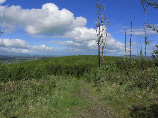 Photo could not load
N4779 : Mullaghmeen Forest Walks -Path running E from Mullaghmeen Hill
Colin Park
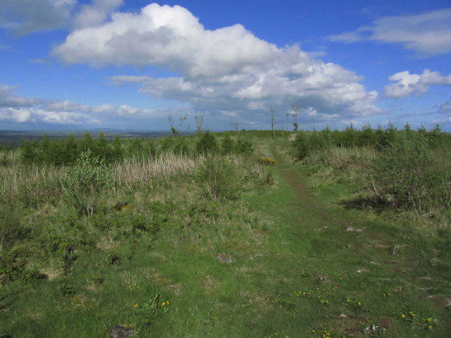 Photo could not load
N4679 : Mullaghmeen Forest Walks - Path running E from Mullaghmeen Hill summit
Colin Park
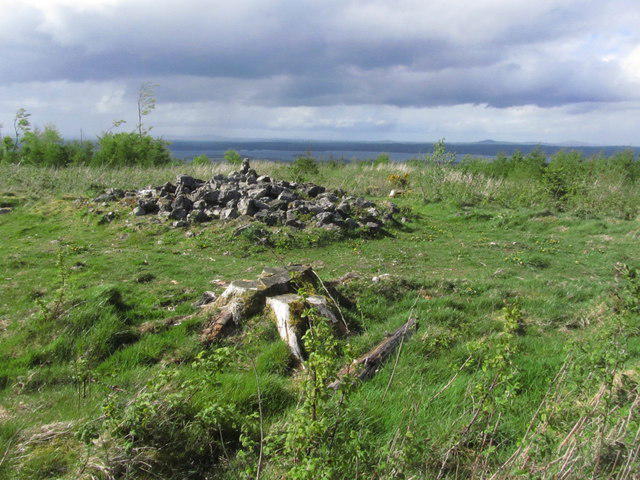 Photo could not load
N4679 : Mullaghmeen Forest Walks - Cairn making Mullaghmeen summit with Lough Sheelin beyond
Colin Park
Hill facts and local notes
Classifications
Elevation
261m
856 ft
Prominence
133m
Coordinates
53.7620, -7.2892
N469793
OS Map
41
At the Summit
The summit features a substantial stone cairn and a wooden observation tower, which adds a touch of adventure to your hike and is perfect for selfies.
Terrain & Geology
Mullaghmeen is primarily composed of sedimentary rocks including sandstone and mudstone, which are indicative of the prehistoric aquatic environments that once thrived here. The geology is characterized by rolling hills and valleys formed by glacial activity.
Views & Scenery
On a clear day, you can see the Mourne Mountains and the Slieve Bloom range, as well as the far-reaching landscapes of Westmeath.
History & Heritage
Name Origin
The name 'Mullaghmeen' is derived from the Irish word 'Mullach' meaning 'summit' or 'hill', combined with 'Min', likely referring to a little or small hill.
Historical Significance
Mullaghmeen is a popular local hiking destination and is part of the rich landscape of ancient Irish mythology and narratives.
Getting There & Facilities
Parking
There is a dedicated car park at the Mullaghmeen Woods entrance, with ample space for visitors.
Public Transport
Limited public transport options; best accessed by car. Nearest bus stop is in the village of Ballinalack.
Nearby Facilities
There are no facilities directly on the mountain; however, Ballinalack has a small shop for refreshments and basic supplies.
Safety Information
Known Hazards
- Uneven terrain can pose a tripping hazard; be cautious of loose rocks in certain areas.
General Safety Tips
- Check weather conditions before setting out
- Carry appropriate clothing and equipment
- Let someone know your planned route
- Take a map, compass, and GPS device
- Carry emergency supplies: food, water, first aid kit, torch
Hills
Some common questions about the hills answered
Are there group walks up Mullaghmeen [Mullach Min]?
Many walkers use Walkmates to join or organise walks with others. You can check for group walks around Mullaghmeen [Mullach Min] through the maps
Are there other walkers around Mullaghmeen [Mullach Min]?
Activity varies by location and time, but Walkmates lets you see whether others have shared walks or shown interest in this area. Find other people through the walking friends search walking friends for Mullaghmeen [Mullach Min] search or of course create your own walk for Mullaghmeen [Mullach Min]
Can I organise a walk to Mullaghmeen [Mullach Min]?
Yes. If there aren’t any walks listed already, you can create a walk and make it available for others to join.
If you're signed up to Walkmates, you can create a walk to Mullaghmeen [Mullach Min].
How do I find a walk up this hill?
There are often multiple ways to walk this hill, depending on experience and route preference. Walkmates helps you explore walks and routes that others have shared.
Can I suggest a new route up Mullaghmeen [Mullach Min]?
Yes. You can suggest or create routes to share with others. Walkmates focuses on the social side of walking, so routes are used to help people organise walks and explore areas together, rather than as detailed navigation tools or route libraries.
Other uses really appreciate knowledgeable walkers sharing their routes. Share your favourite route to Mullaghmeen [Mullach Min] here
The is an error or something incorrect about this hill. How do I let you know?
We always strive to keep the information on Walkmates as accurate as possible. If you find an error, please let us know through the contact form and we'll aim to correct it as quickly as possible
Community Discussion
Comments
Location
![Mullaghmeen [Mullach Min] location map](https://cdn.walkmates.com/hill-maps/hill-sources/20688/53.76203_-7.28918.png)
Grid reference: N469793
View on OpenStreetMapOpens a map in a new tab, centred on the hill.
No comments yet. Be the first.